Blogia
Our 6th grade Blog

SOCIAL AND NATURAL SCIENCE

CHRISTMAS PROJECT - National Park


1. Choose a Nature Reserve or National Park in Spain.

2. Search for information about the park in reference books and/or the Internet.

3. Make a poster in a piece of cardboard with the information about the park including:

              - Name of the park. 

              - When it was named National Park or Nature Reserve.

              - Location.

              - Area.

              - Landscape.

              - Physical relief.

              - Bodies of water in the park or around it.

              - Vegetation.

              - Animal life.

              - Interesting facts.

4. Decorate the poster with pictures of the landscape, vegetation and animal life of the park.

5. Don’t forget to be clean and neat.

6. Be ready to present it to your classmates!!


Landscapes in Spain - QUESTIONS

  1. Write down the names of the mountain ranges in the centre of the peninsula.
  2. Write down the names of the mountain ranges bordering the centre of the peninsula.
  3. Write down the names of the mountain ranges outside the centre of the peninsula.
  4. Which is the highest peak in Spain? Where is it located?
  5. Name the major rivers that flow into the Atlantic Ocean.
  6. Name the major rivers that flow into the Cantabrian Sea.
  7. Name the major rivers that flow into the Mediterranean Sea.
  8. Which two rivers have got extensive lowlands?
  9. What are the main characteristics of the rivers that flow into the Atlantic Ocean?
  10. Which rivers carry a constant volume of water? Explain why.
  11. Why do we need to create nature reserves?
  12. What is a humanized landscape? Is there another name for it?
  13. What types of plants can be found in the deciduous forest in Spain?
  14. Where do we typically find brown bears in Spain?
  15. What type of plants are heather and goose?
  16. In which type of landscape does the Iberian lynx live?
  17. What mammals can we see in Spain’s alpine landscapes?
  18. Why is there a variety of landscapes, vegetation and animal life in the Canary Islands?
  19. What is a plan of a place? What do we use it for?
  20. What is a map? What do we use it for?

Spain: Rivers and Types of Landscapes

Click here to see the table of the Rivers in Spain.

Click here to see the table of the types of Landscapes in Spain.

Mapa interactivo de los Parques Nacionales de España

GEOGRAFÍA

A través de estos mapas interactivos os ofrecemos una amplia gama de recursos educativos para poder conocer la geografía española a todos los niveles de una manera amena.

Pinchad en la imagen para acceder a los juegos.

PHYSICAL GEOGRAPHY OF SPAIN

PHYSICAL GEOGRAPHY OF SPAIN

Click here to download more Maps of Spain.

Weather and Climate - QUESTIONS

          
  1. Define weather and climate.
  2. What are the four main atmospheric conditions?
  3. What is temperature? Which tool do we use to measure it?
  4. What is precipitation? Which tool do we use to measure it?
  5. What is wind? Which tool do we use to measure it?
  6. What is atmospheric or air pressure? Which tool do we use to measure it?
  7. What are the factors that influence the climate?
  8. How much does the temperature change when you climb a mountain?
  9. Why are winters usually milder in coastal areas?
  10. Name the three general categories of climate in the Earth and their specific climates.
  11. Name the climate zones in Spain.
  12. Write down the main characteristics of the Continental Mediterranean climate in Spain.
  13. Write down the main characteristics of the Oceanic climate in Spain.
  14. Write down the main characteristics of the Mountain climate in Spain.
  15. Write down the main characteristics of the Subtropical climate in Spain.
  16. Write down the main characteristics of the Mediterranean climate in Spain.
  17. What is the main cause of climate change today? What are the main consequences?
  18. Which are the effects of extreme atmospheric conditions?
  19. What do we call a long period of time without any rain?
  20. What happens when carbon dioxide accumulates in the Earth’s atmosphere?

THE GREENHOUSE EFFECT

THE GREENHOUSE EFFECT

A guided tour of the BIG QUESTIONS:

What is the greenhouse effect?

What does global climate change mean?


SPAIN'S CLIMATE ZONES

SPAIN'S CLIMATE ZONES

The image of Spain’s climate abroad has traditionally been one of blue skies and sun, while in reality it is as varied as the country’s geography. At least five different climate zones characterize the Spanish climate due to the Iberian Peninsula’s position between tropical (hot) and polar (cold) wind currents.

Click on this link to copy the table of Spain’s Climate Zones we’ve seen in class.

THE EARTH'S CLIMATE ZONES

THE EARTH'S CLIMATE ZONES

Didn’t you have time to copy the Earth’s Climate Zones Chart?

Do you need to check it?

Click on this link then.

CLIMATE ZONES

MAKE YOUR OWN WEATHER STATION

MAKE YOUR OWN WEATHER STATION

Meteorologists study the weather by recording and analyzing data. You can become an amateur meteorologist by building your own weather station and keeping a record of your measurements.


WEATHER and CLIMATE

LATITUDE AND LONGITUDE

Planet Earth - QUESTIONS

                
  1. Name and define the three parts of the Earth.
  2. What do we call the gaseous layer that surrounds the Earth? Name its layers.
  3. Which layer of the atmosphere reflects radio waves?
  4. What is the ozone layer?
  5. Which are the layers of the geosphere? Which one is mostly made of iron?
  6. Where can we find water in a liquid state on the Earth
  7. What are the properties of minerals?
  8. How are metamorphic rocks formed?
  9. What does the process of erosion do to rocks?
  10. How do sedimentary rocks become metamorphic rocks?
  11. Classify the following rocks by their origin: conglomerate, basalt, slate, granite, carbon, sandstone.
  12. What do we call magma when it flows out of a volcano?
  13. What are the parts of a volcano?
  14. Why are areas and distances distorted on maps?
  15. What is another name for the Prime Meridian?
  16. Define latitude and longitude.
  17. What is the latitude of the equator?
  18. What are meridians? And parallels?
  19. Are meridians circular or semicircular?

THE ROCK CYCLE

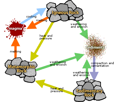
The Rock Cycle is a group of changes. Igneous rock can change into sedimentary rock or into metamorphic rock. Sedimentary rock can change into metamorphic rock or into igneous rock. Metamorphic rock can change into igneous or sedimentary rock. 

Igneous rock forms when magma cools and makes crystals. Magma is a hot liquid made of melted minerals. The minerals can form crystals when they cool. Igneous rock can form underground, where the magma cools slowly. Or, igneous rock can form above ground, where the magma cools quickly.

Image displaying the Rock Cycle.  Please have someone assist you with this.

When it pours out on Earth’s surface, magma is called lava. Yes, the same liquid rock matter that you see coming out of volcanoes.

On Earth’s surface, wind and water can break rock into pieces. They can also carry rock pieces to another place. Usually, the rock pieces, called sediments, drop from the wind or water to make a layer. The layer can be buried under other layers of sediments. After a long time the sediments can be cemented together to make sedimentary rock. In this way, igneous rock can become sedimentary rock.

All rock can be heated. But where does the heat come from? Inside Earth there is heat from pressure (push your hands together very hard and feel the heat). There is heat from friction (rub your hands together and feel the heat). There is also heat from radioactive decay (the process that gives us nuclear power plants that make electricity).

So, what does the heat do to the rock? It bakes the rock.

Baked rock does not melt, but it does change. It forms crystals. If it has crystals already, it forms larger crystals. Because this rock changes, it is called metamorphic. Remember that a caterpillar changes to become a butterfly. That change is called metamorphosis. Metamorphosis can occur in rock when they are heated to 300 to 700 degrees Celsius.

When Earth’s tectonic plates move around, they produce heat. When they collide, they build mountains and metamorphose (met-ah-MORE-foes) the rock.

The rock cycle continues. Mountains made of metamorphic rocks can be broken up and washed away by streams. New sediments from these mountains can make new sedimentary rock.

The rock cycle never stops.


Layers of the Earth

Click on the image to follow the steps to make this model of the layers of the earth in plasticine.

The layers of the ATMOSPHERE

Unit 2 - PLANET EARTH


 In this unit we are going to learn the following contents:

  • Value of water for life and knowledge of its adequate and inadequate uses.
  • Parts of the Earth: atmosphere, geosphere and hydrosphere. Definitions.
  • Components and layers of the atmosphere.
  • Materials and layers of the geosphere. Properties of minerals. Types of rocks according to their origin.
  • Phenomena produced by the energy inside the Earth.
  • Minerals and their basic characteristics.
  • Identification and representation of the layers of the atmosphere and their characteristics (troposphere, stratosphere, ionosphere).
  • Identification and representation of the layers of the geosphere (crust, mantle and core).
  • Classification of different kinds of rocks according to their origin (volcanic, sedimentary, metamorphic).
  • Recognition and representation of a volcano and its basic parts.
  • Representation of the Earth in different forms.
  • Recognition of the basic imaginary lines of the Earth (Equator, meridians and parallels).